What Is a Jökulhlaup? Understanding Iceland's Glacial Outburst Floods
Iceland is a land shaped by the powerful forces of fire and ice. Many volcanoes lie beneath enormous glaciers, geothermal heat melts ice from below, and glacial rivers carry water and sediment across vast landscapes. Furthermore, sometimes, these forces combine to create one of Iceland's most remarkable and powerful natural phenomena: The Jökulhlaup, or glacial outburst flood.
The Icelandic word jökulhlaup has become internationally recognized in the scientific community because Iceland is one of the world's most important places for studying these extraordinary events. Which is the sudden release of water beneath glaciers to enormous floods associated with volcanic eruptions, jökulhlaups have played an important role in shaping Iceland's landscape and geological history.
Within, Katla UNESCO Global Geopark, the relationship between glaciers, volcanoes, and glacial floods is particularly significant. Likely because beneath Mýrdalsjökull glacier lies Katla... One of Iceland's most active volcanic systems. Throughout history, eruptions beneath the glacier have generated enormous quantities of meltwater, producing some of the largest glacial outburst floods ever recorded!
But what exactly is a jökulhlaup, how does it happen, and why is it so important to understanding Iceland's natural environment?
What Does Jökulhlaup Mean?
The word jökulhlaup comes from two Icelandic words: Jökull, meaning glacier, and Hlaup, meaning a run or rush. Together, they describe a sudden release of water from a glacier. But in scientific terminology, a jökulhlaup is known as a glacial outburst flood. These events occur when water that has accumulated beneath, within, or alongside a glacier is suddenly released by an event under the ice cap.
Unlike ordinary glacial rivers, which typically carry meltwater away gradually... Rather, a jökulhlaup can release enormous volumes of water over a relatively short period. Depending on its source and size, a flood may last anywhere from several hours to several weeks. Jökulhlaups vary in size. In fact, some are relatively small, while others can produce extraordinary flows capable of transporting massive ice blocks, volcanic material, rocks, and sediment across landscapes.
According to the Icelandic Meteorological Office, some historical jökulhlaups associated with Katla have reached peak discharge rates of approximately 100,000 cubic meters of water per second. For perspective, that is comparable to the average flow of the Amazon River. Further, these events demonstrate just how powerful the interaction between glaciers and volcanic systems can be. Source: Icelandic Meteorological Office.
How Does a Glacial Outburst Flood Happen?
Jökulhlaups can develop in several different ways, but they all involve the sudden release of water that has accumulated inside or around a glacier. Meanwhile, one of the most fascinating aspects of Iceland's geology is that glaciers can conceal enormous pools of water beneath their ice.
There are several ways this water can accumulate and eventually escape...
1. Geothermal Activity Beneath a Glacier
Iceland sits along the Mid-Atlantic Ridge, where tectonic plates are gradually moving apart. This geological setting contributes to extensive volcanic and geothermal activity throughout the country. In some areas, geothermal heat beneath glaciers continuously melts the ice above it. Over time, meltwater can collect in depressions beneath the glacier, forming subglacial lakes.
Additionally, as water accumulates, pressure and other changes in the drainage system can eventually cause the lake to drain suddenly, producing a jökulhlaup. For example, the eastern and western Skaftá ice cauldrons beneath Vatnajökull are areas where geothermal activity contributes to the formation of subglacial lakes.
2. Volcanic Eruptions Beneath Glaciers
Next, the most dramatic cause of a jökulhlaup occurs when a volcano erupts beneath a glacier. When hot magma comes into contact with glacial ice, enormous amounts of ice can melt very quickly. The resulting water may accumulate beneath the glacier before escaping through channels or beneath its edges. But, depending on the size and intensity of the eruption, these floods can become extraordinarily powerful!
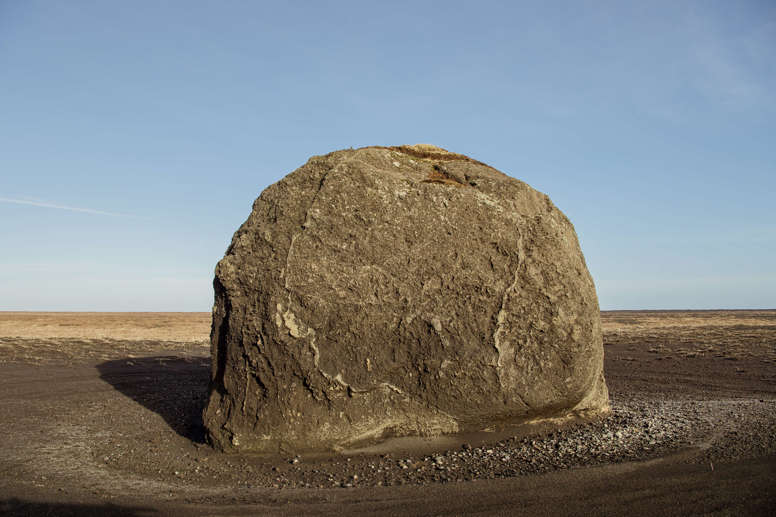
This is particularly important in Katla Geopark, where the Katla volcanic system lies beneath Mýrdalsjökull glacier. Historically, eruptions at Katla have generated enormous glacial outburst floods that have travelled across the surrounding lowlands. To illustrate, it has brought down massive amounts of material to lengthen the coastline and massive rocks too!
3. Water Escaping from Ice-Dammed Lakes
Although, not all jökulhlaups are caused by volcanic activity. Glaciers sometimes block the natural drainage of valleys, creating lakes that are held in place by ice. These are known as ice-dammed lakes. For instance, as the water level rises, pressure can build against the ice dam. Eventually, water escapes through or beneath the glacier, releasing the stored water downstream.
In addition, an example of this out east is Grænalón, associated with Skeiðarárjökull, is an example of an ice-dammed lake that has produced glacial outburst floods. This showcases that jökulhlaups are not exclusively volcanic phenomena. They are also a natural part of how glaciers store and release water.
Are Jökulhlaups Dangerous?
Depending on their size and location, jökulhlaups can be extremely dangerous. After all, a sudden release of water from beneath a glacier can cause rapid flooding, destroy infrastructure, erode riverbanks, and transport enormous quantities of sediment and debris. In some cases, the floodwater can carry large ice blocks and volcanic material, making the flow particularly destructive.
In South Iceland, the areas surrounding Mýrdalsjökull have historically been affected by glacial outburst floods associated with Katla. For example, Katla's rock was brought down in the 1918 eruption and the coastline was lengthened.
For this reason, monitoring and emergency preparedness are essential parts of living in and visiting Iceland. Visitors should always follow official safety information, road closures, and instructions from local authorities. Never attempt to approach floodwaters or enter restricted areas to photograph glacial rivers during unusual conditions.
The Icelandic Meteorological Office and Icelandic Civil Protection provide important information about volcanic activity and natural hazards. You can find current information at Icelandic Meteorological Office and Icelandic Civil Protection.
Celebrating Earth Heritage
How to visit the Katla Geopark
Katla UNESCO Global Geopark is in central South Iceland