Impressive 200m Deep Gorge
Markarfljótsgljúfur & Markarfljótsaurar
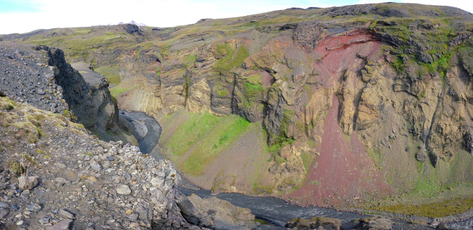
Markarfljótsgljúfur is about 10 km long and up to 200 meters deep, and the upper 5 km are buried in palagonite tuff, while the lower 5 km are buried in a lava field and/or along the lava edge. Another canyon, Tröllagjá, is also found in the same lava field just north of Markarfljótsgljúfur canyon. Both canyons were formed by large glacial outburst floods and numerous other flood formations can be found in the area, such as ancient channels, gullies and sediments.
There are three types of glacial outburst floods that have occurred in the area; due to volcanic eruptions in the Markarfljót basin, due to the draining of lagoons in the Markarfljót basin, and due to volcanic eruptions in Katla volcano underneath Mýrdalsjökull ice cap. The largest flows are caused by volcanic eruptions under Mýrdalsjökull, which normally go through Entujökull outlet glacier, and at least 10 large flows have come from the western side of Mýrdalsjökull in the last eight thousand years.
Markarfljótsgljúfur was not carved all at once, but by several floods that carved different parts of the canyon. The upper part was carved in a flood about 7500 years ago and the lower part began to form in a flood about 4400 years ago, along with Tröllagjá. The formation of Markarfljótsgljúfur then continued in a flood about 3500 years ago and likely reached its present shape during a flood about 2000 years ago. However, it is not fully clear when the canyon reached its present shape, and it is likely that a younger flow had some influence, and Tröllagjá canyon, for example, reached its present shape during a flood about 1600 years ago.
Markarfljót is a glacial river that has its source on the west side of Torfajökull and Mýrdalsjökull glaciers but also has many tributaries and the river's catchment area is about 1200 km2. The river then passes through Markarfljótsgljúfur canyon and once on the lowlands the river begins to disperse more and forms the Markarfljótsaurar flood plain while eventually flowing into the sea at the eastern side of Landeyjarsandur sand plain.
The river, together with the glacial outburst floods that go into the river when it erupts in Eyjafjallajökull volcano and the north-western part of the caldera of Katla volcano, has built up the flatlands east of Hvolsvöllur. However, the river has also caused a lot of erosion over the centuries, and on May 6th, 1910, work was started on the first river defense to try to contain the river.
The defensive wall was at Seljalandsmúli and was about 700 m long and was made to prevent part of the river from flowing east. More walls have been built, most of them between 1930 and 1950, and today there are about 40 of them. The current bridge was inaugurated in 1992, but it was preceded by the bridge near Litla-Dímon, which was inaugurated in 1934.
Directions to the Highland Area Markarfljótsgljúfur (July 8-September 1st) 4x4 Rated for F-RoadsOnly-
Celebrating Earth Heritage
How to visit the Katla Geopark
Katla UNESCO Global Geopark is in central South Iceland